How to Read Marine Navigation Charts [A Guide]
How do you know how to get to where you're going on the water? In most cases, you can't take a right at the next light or simply ask Siri for directions to the next dock to refuel your boat.
That's where marine navigation charts come in! They are your "Siri" for traveling the waterways to get to your favorite fishing spot, another marina, or anywhere you need the water to take you.
So, what are nautical maps? How do you read marine navigation charts? Today, we'll answer these questions (and more) to help you navigate the waters using these maps.

What Is a Nautical Chart?
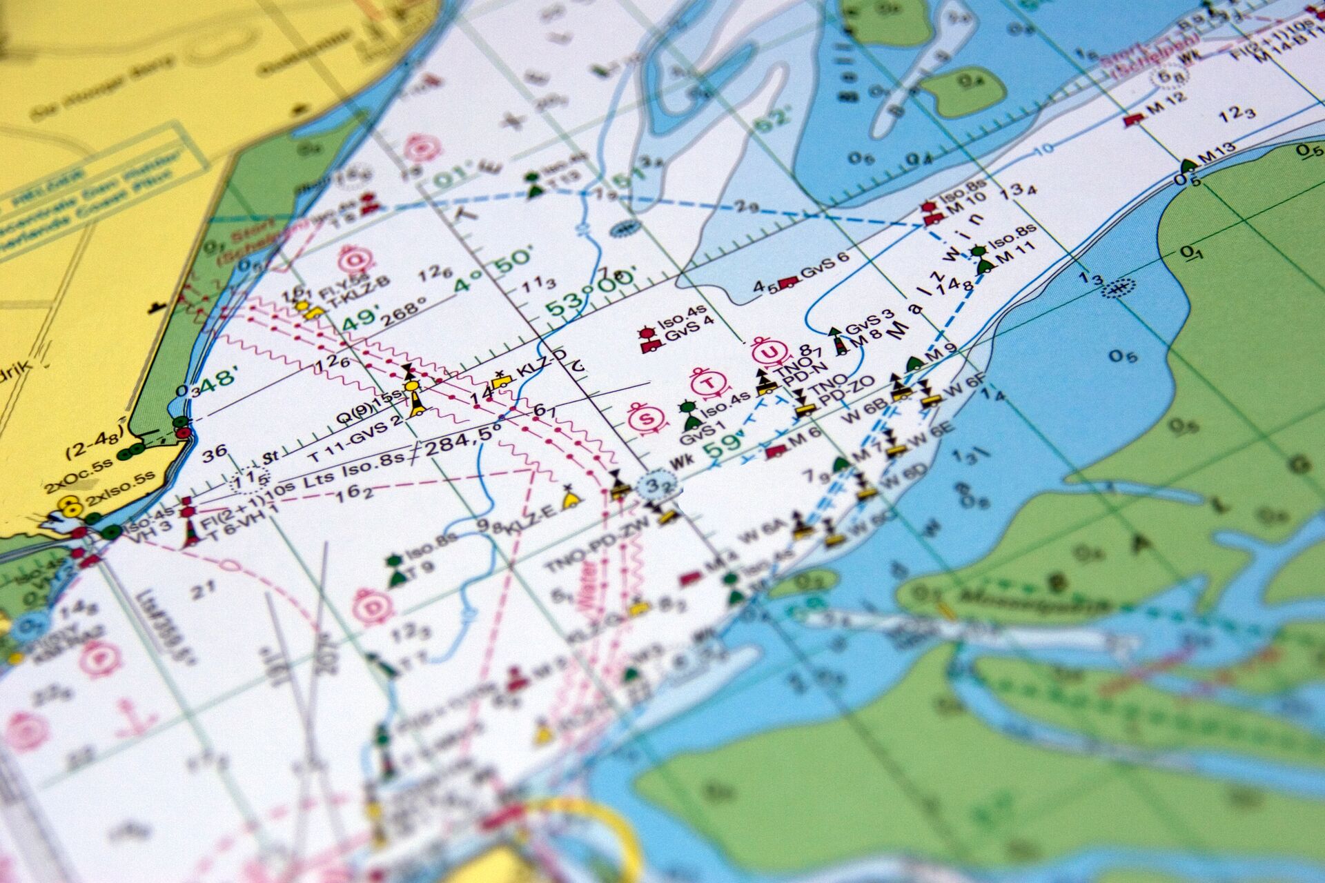
A nautical chart (or marine navigation chart) provides a wealth of information concerning the shoreline, water depths and seafloor contours, obstructions and other hazards to navigation, characteristics of Aids to Navigation, and a host of other pertinent details essential for safe navigation.
The National Oceanic and Atmospheric Administration’s (NOAA) Office of Coast Survey creates these charts. However, while The Office of Coast Survey creates the charts, they no longer print the charts.
A map, however, is different than NOAA charts. Created by the U.S. Geological Survey (USGS), a map focuses on landforms and is usually represented by topographical information. Examples of maps are road maps and atlases.
What Are the Key Elements You'll Find on a Chart?
No matter the chart scale, you'll find similar features on each chart to assist in reading marine navigation charts.
These include:
- Scales
- Latitude and Longitude
- Compass Roses
- Aids to Navigation
- Depth of Water
- Hazards and Obstructions to Navigation
If close enough to shore, harbor facilities and significant natural or man-made features will also be shown.
What Scale Chart Do You Need?
The scale of a chart is defined as the ratio of a given distance on the chart to the actual distance represented on Earth.
- Large-scale charts show greater detail of a relatively small area.
- Small-scale charts show less detail but cover a larger area.
The closer you are to shore, consider using a more detailed (larger-scale) chart. Charts are categorized into six groups, and their names also hint at the chart scale's intended purpose.
These groups are (in order from largest to smallest scale):
| Navigational Purpose | Scale Range |
| Berthing | 1:2,000 |
| Harbor | 1:12,000 |
| Approach | 1:45,000 |
| Coastal | 1:180,000 |
| General | 1:700,000 |
| Overview | 1:3,500,000 |
So, for example, a Harbor Chart with a scale of 1:40,000 indicates 1 inch on the chart equals 40,000 inches on Earth, or just over .5 nautical miles on the chart (.54859611, to be specific). Conversely, a Coastal Chart with a scale of 1:350,000 means 1 inch is 350,000 inches on Earth or 4.8 nautical miles.
Latitude and Longitude
Now that you have the correct scaled charts for your adventures, you must determine where you are. There are a couple of ways to find out, but the preferred method is knowing your Latitude and Longitude (Lat/Long).
Smart devices and handheld GPS devices are the most common sources unless the boat is equipped with a GPS unit installed.
It’s important to understand the following:
- Latitude and Longitude are expressed in Degrees (°), Minutes (‘), and Seconds (“)
- Latitude is labeled either North or South in reference to the equator. Example: 41°53’ 22” N
- Longitude is labeled either East or West in reference to the Prime Meridian. Example: 87° 35’ 26” W
Together, your location would read as: Lat 41°53’ 22” N, Long 87° 35’ 26” W.
The Latitude scale is on the chart's left and right edges. The Longitude scale is found along the top and bottom edges of the chart.
To find Lat 41° 53’ 22” N Long 87° 35’ 26” W on a chart, start by locating Lat 41° 53’ 22” N using the Latitude scale found on either the right or left side of the chart. Then, find Long 87° 35’ 26” W on the Longitude scale along the top or bottom of the chart.
Your position is where the lines bisect!
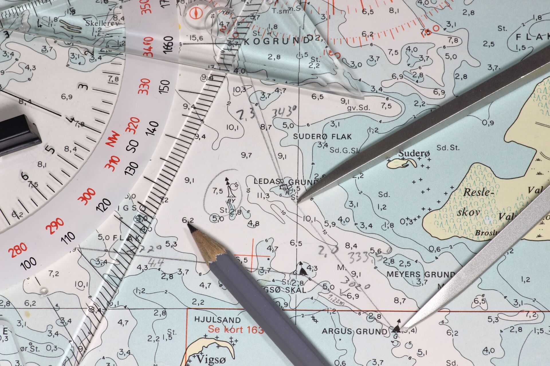
Compass Rose
Found on every chart and often in multiple locations, the Compass Rose visually orientates cardinal directions to assist in plotting courses for navigation.
It contains two concentric circles:
- The outer ring represents True North
- The inner ring Magnetic North
Towards the center of the compass rose will be the calculated variance between True and Magnetic North and its anticipated annual increase.
Aids to Navigation
Aids to Navigation are a simple arrangement of colors, shapes, number, and light characteristics that mark navigable channels and waterways, and any obstructions or hazards preventing safe navigation.
A lateral system is implemented on both beacons and buoys to indicate which side of the channel a vessel should pass when entering from seaward. Color is the most important characteristic easily recalled by the 3” R” rule: Red Right Return.
Water Depth
Knowing if the water is deep or too shallow for boating is crucial — and you can use a marine chart to help you determine the water's depth.
It is essential to know if water is measured by feet, fathoms, or meters on the chart. This information is in magenta print on at least one of the four corners of the chart.
Water depth on the chart is noted in a couple of ways: Color Contours and Numbers. Deep water is white on the chart, while shallower water is indicated by up to four darkening shades of blue, the darkest blue being the shallowest.
Hazards and Obstructions
Whether a large rock or a reef, a sunken ship, or an offshore wind farm, there are a host of navigational chart symbols on the chart that represent hazards and obstructions to navigation. These symbols and abbreviations are a type of shorthand for the physical characteristics of the chart and aid in navigation.

How to Plot a Basic Course on a Chart: 4 Steps
Knowing how to read a marine chart is one thing. Keep reading to learn how to use one to plot your course!
1. Find Your Locations
Use all tools at your disposal — GPS, Landmarks, Navigational Aids — to plot your current position on the chart using the Latitude and Longitude scales on the side of the chart.
Then, find your destination and plot that location.
2. Plot Your True Course
With your current location and destination found on the chart, line both points up with your parallel rule and draw a line between the two.
Validate whether the plotted course is safe by interpreting the chart symbols. Are there any hazards or obstructions that require a waypoint and course change? Is there a defined channel required for safe passage?
If there are no changes to the plotted course, place the parallel rulers back on the line you just drew and then walk the parallel rule to the nearest compass rose until it intersects the center of the compass rose. Remember which direction you are heading and mark the outside of the compass rose in the direction you are heading.
3. Calculate the Variation and Deviation
The chart is always true — meaning we always use the true ring in the compass rose — but we steer a course by compass. Because of variances in the Earth's magnetic field and deviation from elements on the boat, we must compensate for these variables using the TVMDC (True heading, Variation, Magnetic heading, Deviation, Compass heading) formula.
So, when moving from True to Compass (TVMDC), add West variation and deviation and subtract East variation and deviation.
4. Determine the Distance
Use your dividers to measure the length of the plotted line in reference to the chart's scale to convert to nautical miles.
While many additional variables can be considered, the four steps outlined above should help you plot a basic course using a marine chart!

Best Practices for How to Read Marine Navigation Charts
What else should you know to understand nautical charts? Staying informed about changes to charts and avoiding mistakes will help you arrive safely at your destination by boat.
Stay Up to Date
The marine environment is dynamic and constantly changing. Charts are accurate, but situations arise. For example, the light to an Aid to Navigation may be out, a hurricane has pushed shoals around, or temporary work is being done requiring increased awareness.
When these things happen, charts must be updated, and it's your responsibility to make sure you have the latest charts. The USCG publishes a weekly Local Notice to Mariners addressing these situations.
Avoid Common Mistakes
Mistakes happen, but try to limit them as best as possible.
To avoid mistakes:
- Practice reading charts.
- Confirm how water depth is defined: feet, fathoms, or meters.
- Is the flashing light sequence on the buoy just off your bow the same as the chart indicates?
- Do you have the correct scale chart for your needs?
- Are you reading the Latitude and Longitude scales correctly?
- Did you exit the compass rose in the correct direction?
Taking time to ask questions and confirm details can keep you on course and safe while on the water!
Learn More About Boating and Navigating Safely with ilearntoboat
Knowing how to read a nautical map (or chart) is an important tool in the art of navigation. We have touched on key elements of the chart from a very general view, but there is more to learn and understand about charting and navigation that comes with more detailed instruction, practice, and time. Allow curiosity to further your knowledge and understanding of the tools required for safe boating.
In addition to understanding marine charts, boat operators need to understand boating safety essentials, including right-of-way, safety equipment, what to do if something goes wrong, and more. ilearntoboat's online boating education course helps you learn everything you need to know in a fun, gamified format. Plus, it's a fast way to get you ready for the water and meet your state's boating education requirements.
Ready to navigate your way to safe boating adventures?
Choose the course for your state, pass the final exam, and then hit the waters (safely) this spring.

Our partners at Wavve make plotting your course easy with their new Online Chart Viewer! Wavve's tool is free with a user-friendly design that makes marine navigation more accessible than ever.
Plus, when you complete your course through ilearntoboat, you can take advantage of Free One-Year Subscription to Wavve Boating (a $59.99 value)! Enjoy premium features while you put your boater education to good use on the waterways.
To unlock your free year of the Wavve Boating app, complete your course, pass the final exam, and then visit your student dashboard for your promo code.